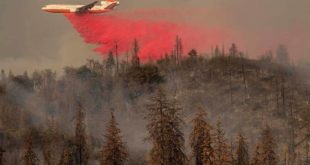
The Owens River Fire Started on the afternoon of September 17th. The fire is burning north of the Owens River Road near Clark Canyon, east of Highway 395. It is burning in sagebrush and Jeffrey pine. Smoke is highly visible from locations throughout the Highway 395 corridor including Bishop, Mammoth …
Read More »Merced students celebrate Constitution Day
Stowell Elementary School students sang patriotic songs Friday in celebration of the signing of the U.S. Constitution. Constitution Day was actually Saturday, so elementary school students ended their week singing “You’re a Grand Old Flag” and “This Land is Your Land.” Video by Sara Sandrik/Merced City School District … Click …
Read More »Neighboring counties voice support for home care workers seeking raises
Susana Saldana cares for her 29-year-old son, who for many years used a wheelchair and now requires a walker. He requires 24/7 attention, and finding a second job isn’t realistic. … Click to Continue »
Read More »Chowchilla proposes Redskin Way for high school road
The city of Chowchilla has moved to hang “Redskin Way” signs on the poles that line the street where Chowchilla High is found, thumbing its nose at the state decision … Click to Continue »
Read More »Attorney takes issue with how district responded to Opinski
An attorney for Greg Opinski said Merced Union High School District violated public information laws in a censure resolution and by denying his client access to email servers. … Click to Continue »
Read More »Owens River Fire (Inyo County) Started 9/17/2016, updated 9/18/2016
Council will vote on police contract for Merced College
The Merced City Council on Monday will consider a contract to provide police services to Merced College in exchange for use of the college’s pool and classrooms for training exercises, … Click to Continue »
Read More »Merced gang unit seizes firearm, 1 arrested
A convicted felon was arrested over the weekend after Merced gang investigators found a rifle and scope “hidden inside his car,” the Merced Police Department reported. Police said 47-year-old Stephen … Click to Continue »
Read More »Old Fire (Mariposa County)
Old Fire Incident Information: Last Updated: September 13, 2016 6:10 pm Date/Time Started: September 13,2016 1:55 pm Administrative Unit: Stanislaus National Forest County: Mariposa County Location: off Old Yosemite Rd, 8 miles east of Greeley Hill Acres Burned – Containment: 150 Acres — 70% Containment Long/Lat: -120.029626/37.75972
Read More »Auburn Fire (Nevada County)
Auburn Fire Incident Information: Last Updated: September 17, 2016 9:14 pm Date/Time Started: September 17,2016 1:40 pm Administrative Unit: CAL FIRE Nevada-Yuba-Placer Unit / Grass Valley Fire Department County: Nevada County Location: Off Auburn Street and Whiting Street, Grass Valley Acres Burned – Containment: 30 acres – 50% contained Long/Lat: …
Read More »Soup Incident (Wildfire)
The Soup Incident near the South Warner Wilderness is made up of five fires near Soup Springs Campground on the Modoc National Forest. Fire personnel and aerial suppression resources from multiple agancies and local governments are on scene of all five
Read More »Old Fire (Butte County)
Old Fire Incident Information: Last Updated: September 18, 2016 7:30 am Date/Time Started: September 16,2016 11:28 pm Administrative Unit: CAL FIRE Butte Unit County: Butte County Location: Off of Old Chico Canyon, west of Forest Ranch Acres Burned – Containment: 30 acres – 70% contained Long/Lat: -121.6998/39.8851
Read More »State Bar urges suspension of former Merced County judge
A former Merced County Superior Court judge who stepped down last year amid allegations of ethical violations may have his law license suspended for two years for failing to disclose … Click to Continue »
Read More »