
Filter - control incident types displayed on map.
Zoom to your location
Reset map zoom and position
Show Legend
Unit Information
24 Fort Missoula Road
Missoula,
Montana
59804
Agency Name: U.S. Forest Service

Agency Abbreviation
FS
24 Fort Missoula Road
Missoula,
Montana
59804
Agency Name: U.S. Forest Service
Agency Abbreviation
FS
Highlighted Activity
Elder 1 FireLolo National ForestFire Information: 406-468-1909https://www.facebook.com/lolonationalforesthttps://inciweb.wildfire.gov/July 26, 2025 Incident Commander: Teo Digiando (Type 3 IC) Location: 7 miles southwest of Frenchtown, MT in Rock CreekStart Date: 07/24/2026Cause: LightningSize: Estimated 318 acres… Read more
Publication Type: News -
Elder 1 Fire Update- 6:30 PM:Increased fire activity has been experienced on the Elder 1 Fire this afternoon as wind speeds of 10 to 15 miles per hour move through the area, seven miles southwest of Frenchtown in the Rock Creek area of the Ninemile Ranger District.The fire has expanded to over 100 acres in size, with active fire behavior being observed, including backing through heavy timber,… Read more
Publication Type: News -
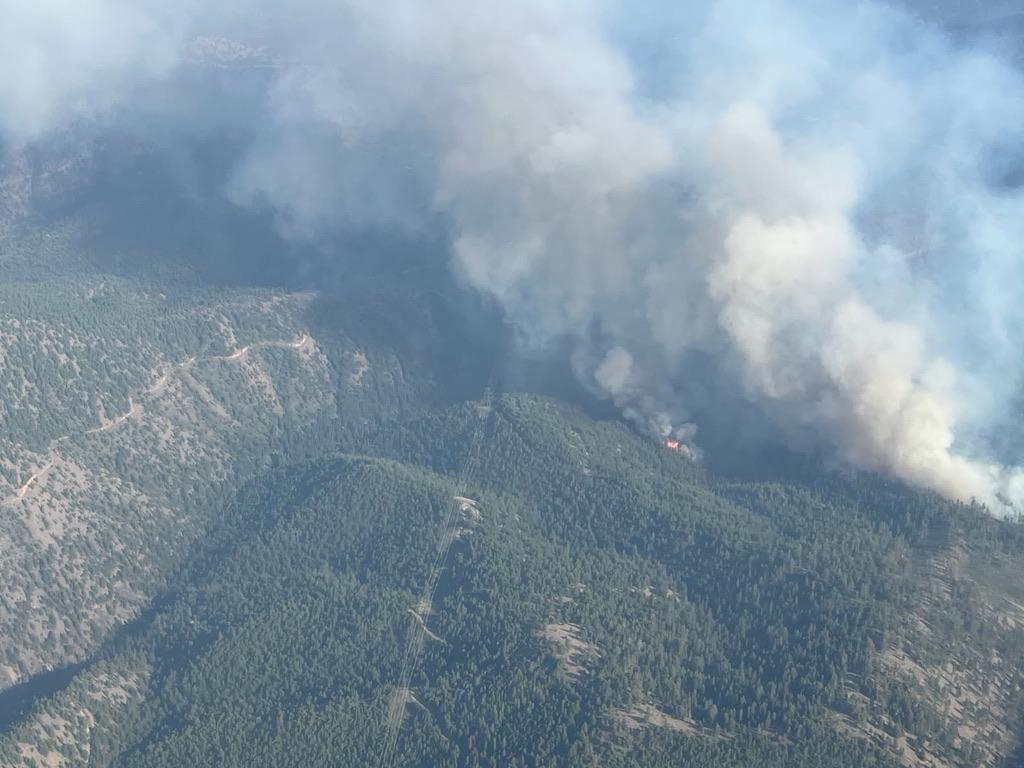
The Elder 1 Fire was detected in the Ninemile Ranger District of the Lolo National Forest, roughly 7 miles southwest of Frenchtown in the Rock Creek area on the afternoon of July 24, 2026. Burning through heavy timber and experiencing active fire activity with afternoon winds.
There was a fire that was detected in the same area, located 3 miles east of Elder 1 Fire, near the Elderberry Gulch area, which is the Elder 2 Fire. Elder 2 is being managed by the Montana Department of Natural Resources and Conservation (DNRC), due to the location falling within the DNRC jurisdiction.
Elder 1 Fire transitioned to a Lolo National Forest Type 3 Incident Management Team on July 25th at 7:00 PM.
| Current as of | Mon, 07/27/2026 - 10:59 |
|---|---|
| Incident Time Zone | Mountain Standard Time |
| Incident Type | Wildfire |
| Cause | Undetermined |
| Date of Origin | |
| Incident Time Zone | Mountain Standard Time |
| Location | 7 Miles west of Frenchtown, MT |
| Incident Commander | Teo DiGiando (Type 3 IC) Lolo National Forest |
| Coordinates |
46° 56' 24'' Latitude
-114° 19' 15 '' Longitude |
| Total Personnel: | 90 |
|---|---|
| Size | 318 Acres |
| Fuels Involved | Heavy Timber, Brush and Grass |
| Significant Events | Active Flanking, Torching and Spotting |
| Planned Actions |
Continue to assess opportunities to access and engage fire with direct tactics with available resources to protect critical values |
|---|---|
| Projected Incident Activity |
12 hour: Windy conditions and poor relative humidity recovery forecasted for the overnight hours will 24 Hour: Hot and dry conditions with lesser winds are forecasted. Fuels, terrain, and weather coupled |
| Remarks |
TFR in place 7/25/2026. Ongoing coordination with MT DNRC, Bonneville Power Administration, Missoula County, and private stakeholders. |
| Weather Concerns | Hot, dry, and windy conditions with little relief in the forecast and poor overnight humidity recovery. |
|---|